Cod Jigging and New Friends!

Hello!  I have just finished building a new computer and am in the process of reviewing and culling thousands of photos from over the years. In so doing I came across one that triggered a special memory of a very special day in a special place.  For whatever reason, we never blogged about it, but have decided it was too good not to share even at this late date.

As many of our faithful readers might recall, back on June 21st of 2017 Marti and I arrived in Newfoundland and Labrador, where we spent most of the summer.  It was a glorious time in a beautiful place filled with wonderful people!  This story takes place in the small town of Winterton, off Trinity Bay on the western side of the Avalon Peninsula on Newfoundland’s east coast. Located there is the Wooden Boat Museum which our friend Suzanne, had told us was a must see.  We arrived late in the afternoon on a Saturday, 15 minutes before closing time.  We decided to wait until morning when we would have plenty of time to see everything.  Hoping to stay the night in the tiny parking lot, we asked inside and the two young people covering the museum said they thought it was fine.  Just to be certain, when we saw an older gentleman just coming outside and clearly part of the boat building staff we asked him too.  Typical of Newfoundlander’s friendliness, he laughed and said, “Why not, it’s just a bit of space!”

The next morning, because the museum didn’t open until 10, we went for a walkabout the town to see what there was to see.  I noticed a couple of men cleaning fish down on the docks and so we wandered over.

20170806_093637

Cleaning fish, which in Newfoundland means cod.

About then another guy, two kids, and a woman showed up and they were all joking and teasing with each other.  As I love a bit of teasing myself, and as they acknowledged us, I started in with a comment or two of my own. Very quickly, we were all laughing and having a good time!  I asked all about what they were doing and how the fishing was, and like most engagements with folks in Newfoundland, we soon felt very welcomed.  Mike, a big guy, and Ed not so much, had been out that morning on Mike’s boat and caught their personal limit of 5 cod apiece. The woman who had shown up about the same time we had wandered over was Mike’s wife Wanda.  Next thing we know, Mike looks at us and asks if we’d like to go cod jigging?  Immediately I thought no way is Marti going to get in a fishing boat on the open water (she doesn’t like boats of any kind) so I hesitated to look over at her.  To my great surprise, she enthusiastically said “Yes”!  The other man laughing immediately says to us, “You know Mike’s just asking you ‘cause your worth 10 more fish, right?”  Ed (not me, the other Ed) laughing says, “Nah, with Wanda, it’s 15 more fish!”  We didn’t care, this was an unexpected treat for us!!

Wanda, Ed, Marti and I boarded Mike’s boat, which had plenty of room for all five of us, and everyone put on a life preserver as we headed out into the bay.  Did I say it was a beautiful day with calm seas that looked like glass?
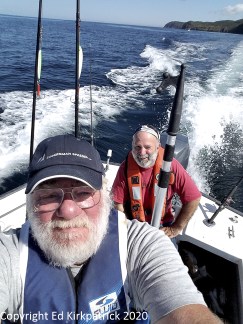
20170806_111339

Ed 1 and Ed 2.

Well, it was and pretty soon each of the three of us was set up with a rod.  Using no bait on the heavy shiny hook, they told us to just throw the line over and let it drop until it hits bottom, about 50 feet down, then reel up the slack.  The jigging is rhythmically and repeatedly jerking ~ jigging ~ the line up a couple feet and letting it drop down again.  While getting the rhythm right takes practice that’s really all there is to it. The cod will hit the shiny hook and you just drag them up to the surface.  They stop fighting very fast, but they are still heavy, and 50 feet is a lot of line.  Mike or Ed netted our catch, slit their throats to bleed them so they taste better and tossed them into the bucket.

20170806_110936

Serious fish!

With a great deal of laughing and teasing, we got to know each other a bit and in under an hour, we all three had our limit! 20170806_113458Then Mike took us on a short tour of the coast. One place Ed (not me) wanted us to see was a naturally occurring quartz figure “77” in the cliff so we motored over to that spot before heading back into the dock.

20170806_112100

Winterton is just inside the cut in the cliffs.

20170806_111130-Edit

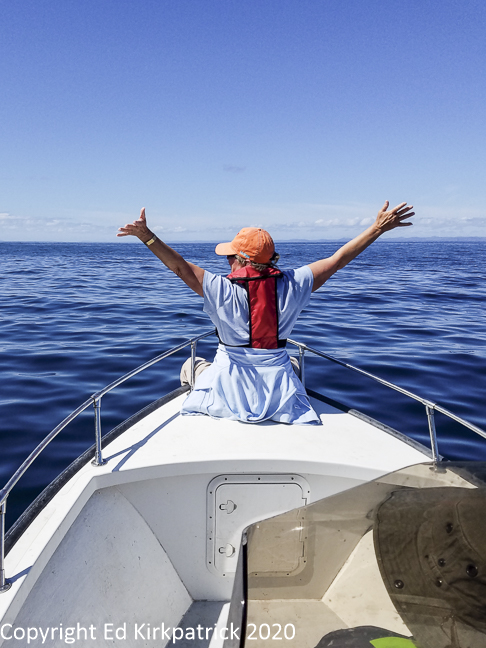
Marti’s Titanic moment! and no sinking was involved.

20170806_112315

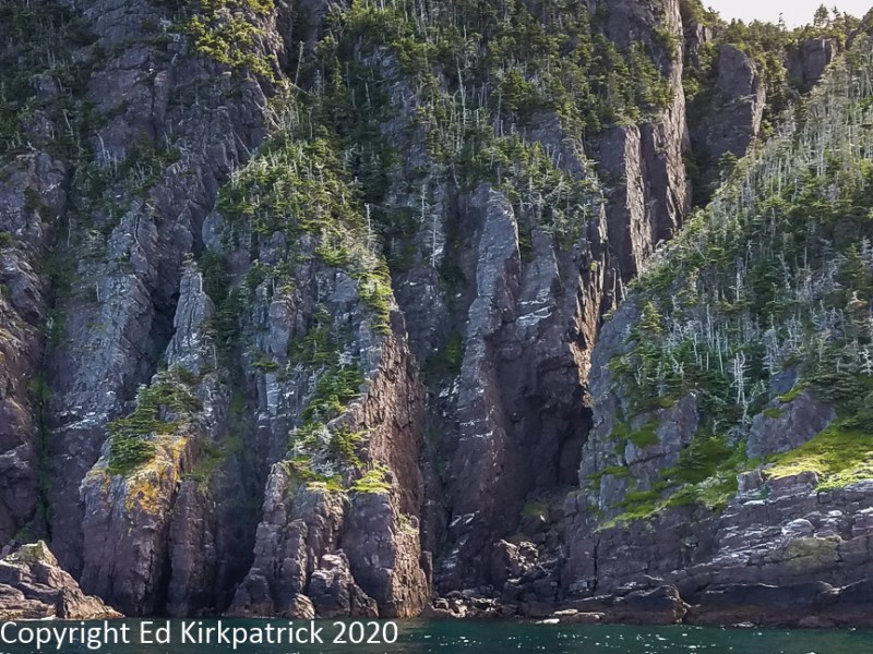
The 77 is dead center just a little bit above the waterline.

Back on shore, Marti and I followed Wanda’s directions and helped empty and clean up the boat while Mike and Ed went about cleaning and filleting the cods.  Fresh out of the ocean, they were the loveliest snow-white filets, much prettier than the color we see at our home grocery.  Mike and Ed made quick work of the 15 large cods and generously offered us our share, but having very limited refrigerator and freezer space we only take a few filets and some cod tongues. I asked if I could take their picture to commemorate the day while Marti ran to the RV where she put together a small packet of our photo blank greeting cards as a thank you.  All too soon, we needed to say our good-byes & thank-yous for our wonderful adventure with new friends.  Ten miles up the road, I suddenly realized we didn’t get their emails and regretted it tremendously.

The following winter while we house-sat for friends in Maryland,  I had an email from Mike. He had found my website info on the back of the cards and reached out to us with the sad news that Ed had suddenly become very ill and passed away that winter.  Mike and Wanda realized that in all the time of their friendship they had no photographs of the three of them together.  Then they remembered I had taken one and hoped we still had a picture.  I did and was so pleased I could send it to them.

20170806_120658

Mike, Wanda, and Ed.

We are good Facebook friends now and surely hope to see them again when we go back to the Rock next summer 2021.  Wanda says the beds are made!


20170806_124314

We did eventually get to the Wooden Boat Museum but for some unexplainable reason, I only took this one photo.  

20170806_102052

Marti and Wanda in transport mode.

20170806_180531

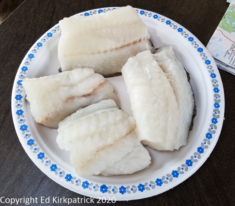
That night’s dinner, YUM!

Grand Tetons ~ Yellowstone

Tags

, , , , , , ,

OKEY DOKEY, after Dinosaur National Monument the plan was to finally go to this Fall’s main destination of Moab, Utah for Arches and Canyonlands and points south.  The route I had worked out included a slight bump over to Grand Junction, Colorado to do the Colorado National Monument Rim Rock Drive.  I had just finished jotting down route numbers and potential campsites when my dear husband says, “Uh oh!  I just looked at the weather and it’s gonna be 90 plus degrees in Grand Junction!!  I think we should go north!”

“OKEY DOKEY,” says I, “where’d you have in mind?”

“I don’t know” says he.

“Well, what the heck, you’ve still not seen the Tetons or Yellowstone and maybe the crowds are just bad, not horrible, whatdaya think?  It will certainly not be 90 degrees!”

“Sure, why not?” was Ed’s answer.  Soooooo, I plotted a route north 😊

With a stop in Vernal, Utah to do laundry at West End Laundromat & Cleaners (highly recommended), we headed north on US RT. 191 which goes through Ashley National Forest and close to Flaming Gorge National Recreation Area where we’re into Wyoming again.  This bit of 191 is lovely and has the unique and fun benefit of posted signs denoting the geological layer and the type of fossils associated with that time period.

To stay with 191 North you have to pop on Interstate 80 East for a bit, then back onto 191 where the pretty countryside becomes barren, flat and windy. Eventually, however there are mountains in the distance and their snowcapped beauty is welcomed.  Just south of Boulder, WY near the Wind River Mountains we stopped for the night at Highline Trail RV Park where we dry camped as the park was full (mostly permanent/workers but clean, nice and recommended).

20190909-_EKP0670

Pretty evening at Highline Trail RV Park.

The next morning, Ed got his temperature change….it was 48* in the rig!  OKEY DOKEY, where’s my fleece 😉  Pretty quickly as we headed north into Bridger – Teton National Forest it really becomes lovely especially when the road starts to follow the Hoback River.

I have mentioned in other blog postings memories of my family’s trip west in 1962.  The Grand Tetons were one of the spots I have held dear in my mind’s eye from that 5 week vacation and I had been feeling some trepidation about seeing these special places years later when everything is so crowded. Of course, the first place one comes to on US191 is Jackson, the sort of ski-town-touristy place Ed and I generally avoid.  It was PACKED and as we continued on I had all fingers crossed.  Sure enough, just as I remember, as we came up the valley, one can’t see the mountains……until one can, and there they are in all their glory!

20190910-_EKP0706-Pano

Le Grand Teton and Ed’s right, a stormy sky makes for nice pictures.

The Colter Bay National Park Service Campground is at the northern end of Grand Teton National Park, and being first come, first served it was our only shot at staying because as expected everything reservable, campground or lodge was booked.  We headed straight there and yippee, got a very nice spot.  Next up, late lunch at the John Colter Ranch House Restaurant next to the campground.  We highly recommend this place, very good food, and the best breakfast potatoes I’ve ever had!

The weather was not ideal, but we never let that stop us as we went on out for a drive, and guess what we found…

20190912-_EKP0841

Tatonka! Isn’t he handsome? 

Next day the weather was really crappy rainy again so we headed out of the park and up US 26/287 into Bridger Teton National Forest.

20190911-_EKP0817

At about 8200 feet, the rain turned slushy.  At 8400 feet it was snowing hard and sticking. We decided to turn around.

20190910-_EKP0693

…and back down at the Tetons, it was just dreary but dramatic.

Not wanting to stop I suggested we drive the 31 miles on up to Yellowstone.  We stopped at Grant Campground where the very nice lady searched and found a single night cancellation for a single site for the next night!  I booked it, and we headed back to GT and the Ranch House for dinner.


After rain off and on all night we woke to some sun and headed off for Yellowstone where we checked into the campground before heading to Old Faithful.

20190912-_EKP0873

Old Faithful was on time and considerably more crowded that when Marti was here in 1962. After watching Old Faithful, we headed up the path of the Upper Geyser Basin.

20190912-_EKP0903

Molten rock or magma may be as close as three to eight miles underground and this magma provides the first ingredient for these thermal features – heat. Water provided by rain and snow is the second.  It seeps down several thousand feet where it is heated.  The third ingredient is the underground cracks that provide a natural “plumbing” system. The superheated water rising through these cracks produces hot springs and geysers.

20190912-_EKP1058

Grand Geyser is in our opinion considerably more magnificent than Old Faithful. Grand is the tallest predictable geyser in the world.  A classic fountain geyser, an eruption can last nine to twelve minutes and reach heights of 200 feet.

After a long day, back at the campground, where, with lots of careful back & forth and a pile of LEGO blocks we got level and settled in for Happy Hour. 😊


The next morning we packed up and got up the road early because our only hope for a campsite was to be in line for the first-come, first-served Norris Campground where sites are often gone by 9AM or sooner.  Once again, yippee, we got a site (and it only took 6 blocks high on the right and 5 high on the left to level)!

Today’s hikes were at the Norris Geyser Basin where we did both Back Basin and Porcelain Basin.

20190913-_EKP1256-Pano

Norris Geyser Basin is the hottest, oldest, and most dynamic of Yellowstone’s thermal areas. The highest temperature yet recorded in any geothermal area in Yellowstone was measured in a scientific drill hole at Norris: 459°F just 1,087 feet below the surface! (NPS)

20190913-_EKP1297-Pano

Porcelain Basin at Norris Basin.  The murky blue pools are saturated with silica, the primary component of glass.  The thermal waters here have the highest concentration of silica in Yellowstone Park.

NOTE:  Yellowstone’s roads form a basic, irregular 8 with the top circle being smaller than the bottom circle. There are 5 “arm” roads that come into the “8”, being the South (from Grand Teton NP), West, North, Northeast, and East entrances. 

From Norris Campground the next day’s drive was north to Mammoth Hot Springs. where parking is a bit of a joke, but after driving around a bit we did finally find a spot.

20190914-_EKP1448

At Mammoth Hot Springs the hot water dissolves carbon dioxide forming a weak solution of carbonic acid (the same stuff that makes your soda pop fizzy).  This solution rises through the limestone dissolving the calcium carbonate which is the primary component of limestone.  At the surface, that calcium carbonate is deposited as travertine which is the rock that forms the terraces you see here.

20190914-_EKP1446

The terraces here at Mammoth are shaped by the volume of water and the slope of the ground. Building up rapidly, travertine causes the features to change quickly and constantly.


After enjoying the Hot Springs we continued on around clockwise to go out the Northeast arm into the Lamar Valley which is famous for its wildlife viewing and fishing in the Lamar River.

20190914-_EKP1561-Pano

Lamar Valley where there are vast herds of Bison.


Backtracking out of Lamar we continued on clockwise through beautiful countryside on our way back to Norris.

20190914-_EKP1628

Away from hot springs and geysers, Yellowstone is even more stunningly beautiful.

20190914-_EKP1569

A black bear sow and her two cubs causing a traffic jam alongside the road.  We also saw a mama grizzly and her second year cub but so far away we didn’t bother to take a picture.

In the morning we headed back south to Grand Teton where it was Sunday with beautiful weather and hence CROWDS and NO PARKING ☹.  Not to worry, we drove out Antelope Flats to Gros Ventre Road where we found the Gros Ventre Slide!

20190915-_EKP1709-Pano

Grand Teton in the sunshine out on Antelope Flats where the view with this old farmstead gives scale to the peaks and the way they just come straight up out of the plain.

20190915-_EKP1717

On June 23, 1925, hurling down the slope at 50 mph, the mile-wide Gros Ventre Slide carried 50,000,000 cubic yards of debris down the mountain and then another 300 feet up the opposite slope. The Slide blocked the Gros Ventre River, and formed a five-mile long body of water.  The rest of the story about the dam collapse and the destruction of the little town of Kelly can be found at this link.  Be sure to read this.

OKEY DOKEY!  It was crowded and we cannot begin to imagine what it’s like during the summer, but it was wonderful to see both of these amazing places.  Absolutely put them on your MVL (Must Visit List) BUT, especially if traveling in your RV, bring your sense of humor, your patience and leveling blocks.  OH, and do it on the shoulder months!


20190911-_EKP0805-Pano

The Snake River and the Grand Tetons which are not visible.

20190912-_EKP0909

Thermophiles, microorganisms ( algae, bacteria, and archaea) that thrive in hot temperatures give color to the water flowing over the rock.  Different temps allow different thermophiles creating different colors.  In 1966 a bacterium was discovered in a Yellowstone hot spring which contributed to DNA “fingerprinting” used in criminal and medical research.

20190912-_EKP0926

Beach Spring boiling furiously in Upper Geyser basin above Old Faithful.

20190912-_EKP0974-Pano

Upper Geyser Basin.

20190912-_EKP0988-Pano

Spasmodic Geyser…  We didn’t name it. It did not spasm while we were there.

20190912-_EKP1000

At Grand Geyser, the spray and mist lays silica on the nearby trees which seeps into them killing the tree but preserving the wood.

20190913-_EKP1119-Pano

A rainbow forms in the steamy morning mist from the fumaroles in this Yellowstone meadow.

20190913-_EKP1153

Yellowstone traffic jam and they are in charge and don’t care how long you have to wait.

20190913-_EKP1353

Nymph Lake.

20190914-_EKP1442

Travertine ridges at Mammoth Hot Springs.

20190914-_EKP1474-Pano

Elk in repose at Mammoth Hot Springs. 

20190914-_EKP1542

In the Lamar Valley, it’s a good idea to watch where you walk. Marti disavows this picture.

20190914-_EKP1616

Waterfalls on the Yellowstone River at Calcite Springs.

20190915-_EKP1708

Backyard bison at Mormon Row on Antelope Flats.

20190915-_EKP1724

The Grand Teton from an Aspen alley on Gros Ventre Road.

20190914-_EKP1435

And that’s all folks! Bye bye!

Beauty & Bones ~ Dinosaur National Monument

Tags

, , , , , ,

When Ed and I set out on this adventure in our beloved Whack-A-Mole Wheels home we had only one destination on our itinerary, the southeastern parts of Utah that we had not been able to explore in 2018 due to the emergency eye surgery in Provo. I had mapped out our route through Medicine Bow (the Scotts Bluff visit being a last second whim) and then a stop at Dinosaur National Monument before heading south for Arches, Canyonlands, etc.  As we came along west, I decided not to bother with Dinosaur….then I decided what the heck let’s go….then I decided nah, let’s skip it.  The morning we headed out from dry camping north of Steamboat Springs (another last second whim visit) south on pretty RT 13 and then west on RT 64 for Rangley CO. I said to Ed, “What the heck, it’s still early and we’re practically there, let’s go to Dinosaur.”  Decisive ain’t I😉

20190906-_EKP0228

Meadows Campground Routt National Forest above Steamboat Springs, Colorado. Fine dry camping.

While I had done a little reading about Dinosaur National Monument, it turns out I had not quite got the details correct.  I knew that there were two separate entrances about 26 miles apart. The first, with the most land area in Colorado, and the second smaller area in Utah.  A couple of miles east of the tiny town of Dinosaur, off US Route 40, I knew that the Colorado entrance, Harper’s Corner Rd, went about 30 some miles in and was an in & out road,( you drive in then back out on the same road). I knew that the road actually went from Colorado into Utah and back into Colorado.  I knew that just getting into the monument required driving a number of miles on a dedicated park service road.  I also “knew” the famous quarry wall exhibit was back in on Harper’s Corner Rd.  We pulled in, skipping the visitor center.  The road starts to climb at once and up and up we drove enjoying the expanding view and the lack of other cars.  At the top the good paved road mostly runs near the rim of the plateau where overlooks afford wonderful views across the surrounding mountains, and deep canyons.

20190906-_EKP0253-Pano

From the plateau Echo Park Overlook on Harper’s Corner Road.

20190906-_EKP0265-Pano

Iron Springs Overlook.  The Green and Yampa Rivers have cut canyons across the landscape which contribute to these magnificent views, this one having been cut by the Yampa River.

I kept telling Ed, “I don’t know where the fossil wall place is, I know it’s supposed to be back a ways.  I’m not sure where?  At least it’s a beautiful drive!” Then we arrive at the end of the road!  We park and get out nodding hello to the handful of other folks.  One gentleman, asks me if I know where the fossil quarry place is, and I allow as I thought it was here but clearly not.  We walk a short way out a path and decide against taking it as it heads down hill and what goes down, has to come up. 😊 We laugh with the guy I spoke with earlier about our joint mistake, but agree it was worth the drive.   I started to get a sneaky feeling about my goof.  Ed and I notice another family and wander over to ask if they knew what the deal was and yup, I really blew it.  The quarry is on the Utah entrance side!!  We all laugh and chatted about the beauty of the place and our confusion.  This man also told us about Green River Campground over in the Utah part where there were a good number of first come, first serve dry camping spots.  Taking our time to stop at the overlooks we skipped coming in, we headed back out for Jensen UT where RT 149 is the road into Dinosaur National Monument (Utah side) and the campground.

20190906-_EKP0324-Pano

Surprise! The Green River flows right next to the Green River Campground! To all the campers, we really recommend this park.  Dry camping with really good water out of the scattered hydrants.

The next morning we drove out RT 149/Club Creek Rd to where the pavement stops.  Here the dirt road forks and we proceeded left on Josie Ranch.  Just a short ways down we pulled over to look at the first set of Fremont Culture petroglyphs.  Further down the road there’s another pull out where we stopped to make the short climb up to the more extensive collection of petroglyphs.

20190907-_EKP0349

Petroglyphs are scratched into the desert varnish on the rocks, while Pictoglyphs are painted or drawn on the rock with natural dye paints.

20190907-_EKP0351

These are considered of the Fremont Culture.

Continuing down the road we arrive at Josie’s ranch. Josephine (Josie) Bassett Morris was born January 17, 1874, in Arkansas. Involved with Butch Cassidy, as well as several other outlaws Josie was married four times, divorcing (and perhaps poisoning one) all her husbands.  Josie moved to homestead here on Cub Creek in 1913.  With the help of her son Crawford McKnight (father husband #2) she built a log cabin and lived here, ranching (cattle rustling) by herself for the next 50 years!  Sustaining a broken hip when a horse knocked her down, Josie finally had to leave her home and died a few months later at age 90!

AR-160329956

This is Josie well into her life at Cub Creek.  Marti had a blast researching her life and intends to keep looking.  We do suggest you have a look for yourselves. Josie, her sister “Queen” Anne Bassett, oh and their mother, were really something, think Butch and Sundance…  Wikipedia…

20190907-_EKP0402

Josie’s cabin has been partially restored although the inside is full of dirt… It is a lovely location for a home though.

Finally, after all the fun we’d already had at Dinosaur National Monument, we drove over to the visitor center (Utah) and took the required shuttle up to see the world famous Carnegie Dinosaur Quarry!

20190907-_EKP0543

This dinosaur fossil bed was discovered in 1909 by Earl Douglass, a paleontologist working for the Carnegie Museum in Pittsburg.  The quarry contains eleven different species of dinosaurs and over the years they have supplied museums around the world.  Odd as it may sound this amazing wall of fossils is now considered repetitious.  While there are digs still very much being done in other locations of the monument this vast pile is no longer being excavated….the world has all of these guys it needs!

I am sooooo glad I woke up and changed my mind!  Fascinating on so many levels and we both agree, put Dinosaur National Monument on your MVL (Must Visit List) and SEE IT ALL!!!


20190906-_EKP0295-Pano

Overlooking Echo Park from a different point of view.

20190906-_EKP0306-Pano

Where’s Marti? Canyon Overlook.

20190907-_EKP0352

Looks just like the Sunday funnies… sort of.  Enormous amounts of scholarship have been done on petroglyphs all over the southwest, but Ed wonders if it wasn’t just some bored prehistoric teenagers out for the afternoon.

20190907-_EKP0369-Pano

Desert lizards, there are a number of them on this wall, but the big one is over six feet long.  He is so impressive that all the brochures have his picture, the lizard not Ed.

20190907-_EKP0383

Marti finds this fascinating because it is so different from so many petroglyphs we have seen. Ed, on the other hand, thinks she looks like Sally from the Peanuts comic strip.

20190907-_EKP0384

Pretty high up on this cliff wall, we saw packrat nets. Debris piles of everything from stones to mud, to any bit of this or that are built into the nest. The packrat uses urine which crystallizes as it dries holding everything together.  Some of the nests have been carbon-dated at 15,000 years old. Home is where the heart is…

20190907-_EKP0387-Pano

Looking down on Whack-A-Mole Wheels on Cub Creek Road from the petroglyph cliff wall.

20190907-_EKP0409

Hiking back up Josie’s box canyon, Marti had to climb up to the peek-a-boo hole in the rocks.  She needed a boost up as it was harder than it looked.

20190907-_EKP0412

The box canyon right behind Josie’s cabin where she corralled her horses and livestock. Now that we know more about her, tucking things into box canyons might be something she learned from some rather nefarious friends! 🙂

20190907-_EKP0497-Pano

The Green River that John Wesley Powell explored on his way to the Colorado River is just beautiful,  strong and clean.  It also in many places appears very green.  The mountain in the middle of the picture is Marti’s new favorite, Split Rock Mountain.

20190907-_EKP0512-Pano

Ed just really liked this big-ass rock overhanging the Green River just up from the campground.

20190907-_EKP0539

Bones, bones and more bones in the Quarry Hall.

20190908-_EKP0547-Pano

Leaving the Green River Campground the next morning rain was on our horizon.  This was a good thing as it helped clean off the gobs of dead grasshoppers we had collected all the way across Nebraska on the front grille and bumper of the rig.


Wyoming ~ In the Medicine Bow Corner

Tags

, , ,

Leaving Nebraska, we took US Route 85 south to Cheyenne, Wyoming where we found Labor Day is taken seriously. Unlike at home where it’s an excuse for another sale, pretty much everything was closed so “labor” could have a day off!  Novel idea!!  We did find the Accomplice Beer Company open and had different but good sandwiches and a tasty Porter.  I even drank one which is really unusual!  Afterwards we headed out of town for Curt Gowdy State Park where we had a nice campsite and even saw the Milky Way.

20190903-_EKP9985

Yes, it was named after the famous ABC sportscaster, Curt Gowdy who was from Green River, Wyoming.

Taking Interstate 80 over to Laramie we picked up RT 130 west across flat prairie towards Centennial where the road starts the steep and lovely climb into Medicine Bow National Forest and the Snowy Range.  We had thought to dry camp at North Fork NF (National Forest) campground but we completely missed it.  Probably too busy looking out the windows, and boy howdy was that a GOOD miss!!  At 10,700 feet, we pulled into NF Sugarloaf Campground where our $5 camping fee got us a million-dollar view!!

20190903-_EKP0019

Our camping spot which came supplied with big logs for the splitting due to the beetle-kill in the area.  We had a lovely evening by the campfire even if it only glowed a dull red due to the lack of oxygen.  

We walked down to Lewis Lake just a bit below the campground and hiked out to Klondike Lakes.

20190903-_EKP0026-Pano

Lewis Lake.

20190903-_EKP0034

Along the path by Lewis Lake.

20190903-_EKP0054-Pano

The Snowy Range reflected.

20190903-_EKP0133

Almost there… and nearing the end of the hike as far as Ed was concerned.  Hiking at 10,700 feet is tiring.

Back at the parking area for Lewis Lake Ed saw a lady who had just finished paddling the lake in her inflatable kayak.  Having never seen one, and being Ed, he started chatting with her, and as she was camped next to us, invited her to stop by for a drink.  She did, and we now have another RV traveling (and photographer) friend, Sally. 😊 Oh and an important PSA… fill all your water bottles here with some really good cold mountain H2O!

On down, I really should say up, RT 130, at the Snowy Range Pass we stopped for the view of Libby Flats.

20190904-_EKP0144-Pano

The Snowy Range Pass at Libby Flats, 10,847 feet elevation.

A few miles more and a stop at Lake Marie and the short trail across the road with a waterfall and trout in the pool!

20190904-_EKP0168-Pano

Lake Marie named for Marie Bellamy who was the first woman elected to the Wyoming Legislature in 1910.

20190904-_EKP0197

The waterfall across the road flowing from Lake Marie.

Medicine Bow National Forest(s) like many of our National Forests, is not actually contiguous acreage but rather acreage, both large and small, that has been designated/preserved with the same name or sometimes a variation of the same name.  In the case of Medicine Bow-Routt (official name and name on maps but not necessarily the entrance signs at the actual NF) the forests are three separate areas which are not connected; Medicine Bow, Routt and Thunder Basin National Grassland now all known as Medicine Bow-Routt.  Oh, and you may have noticed, GRASSLAND there in the third one.  Yup, just to further confuse folks a National Forest may not be a forest at all!😉

Anywho, I inserted the above so you’d understand why we left the Snowy Range, Medicine Bow NF on RT 130, turned right on onto RT 230 to the town of Encampment where we took RT 70 to go into Medicine Bow-Routt National Forest (part 2) 28 miles from MB-RNF (part 1)!  This second one was not nearly as pretty as the first MB-RNF but it did get us closer to where we wanted to go!  There are in this NF six, ‘sites” which are locations of former mining towns and we stopped at Battle for a brief look.

20190904-_EKP0200

All that’s left of the town of Battle at the summit of Battle Pass.

Mostly there is nothing to see but the Gazetteer marks them and sometimes they can be lots of fun, depending on what is left, or if one is a big history buff.

All in all, absolutely put the Snowy Range on your MVL (Must Visit List), it’s just gorgeous!!

NOTE RV’ers: There are several campgrounds along RT 70 in the 2nd NF but they are very small and/or nonexistent, at least we just couldn’t find them.  We spent the night in Craig at a KOA, something we generally avoid.

We’ll stop here with this posting, but I will give you a heads up… next blog we’ll talk about really old things, and more wonderful countryside as we bounce back and forth between Colorado and Utah.


20190903-_EKP9989

Overland Trail marker on the way to Medicine Bow.  In 1825 William Ashley and members of the Rocky Mountain Fur Company traveled this general route but it was little used until 1862 when Ben Holladay relocated the Overland Stage here to avoid Indian attacks happening further north.

20190903-_EKP9995

A pretty stream near the beginning of Medicine Bow National Forest.

20190903-_EKP0037

The trail heading back to Klondike Lakes.

20190903-_EKP0077

Snow!

20190903-_EKP0071

Marti was gonna make a snow angel but she didn’t want a wet ass.

20190903-_EKP0079-Pano

Klondike Lakes.  There are three of them…

20190903-_EKP0088

Ed had gone as far as he was going to go but he’s in the picture! Can you find him?

20190903-_EKP0130

Parry’s Primrose grows in the snowmelt!

20190904-_EKP0199

The pool below the waterfall below Lake Marie and Ed without a fishing rod.  Next trip.

20190904-_EKP0211

Fishing here in 1878, Thomas Edison’s attention was drawn to the fiber of his bamboo fly rod which he later tested as a suitable filament for his light bulb.  As we all know, he used tungsten in the end.

20190904-_EKP0213-Pano

Coming down from Battle Pass, not a bad view.

20190903-_EKP0132

Something so pretty growing in such cold, cold water. We should all be so hardy.

A Bit of Western Nebraska

Tags

, , , , , , ,

HELLO EVERYONE!!  Nope, we did not fall off a cliff and yes this is an Ed & Marti on the road blog post, but first apologies and explanations 😊 Those of you who follow us might remember that last spring (2018) we were in Utah when Ed had emergency surgery in Provo for a detached retina.  Our son Kevin and DIL Za bought their first house in the middle of all this.  A fixer-upper in Washington D.C.  with a lot more fixer than anticipated.  Ed, in particular, was very frustrated he was not there to help or at least commiserate in person. (Right off they tackled the biggest problems themselves, handled them very well and will someday with more work have a real gem.)  After clearance from the Utah surgeon we booked home, checked in with a D.C. cataract surgeon (a guarantee to be needed after detached retina surgery) and headed north to mostly Quebec, Lake Superior, and the Michigan Upper Peninsula.  Back home in the early fall of 2018, Ed had successful cataract surgery as expected.   While traveling we have always kept an eye on land and houses back home.  This time however we both acknowledged that unexpected health issues that have brought us home over the 4 years on the road, an OK but not wonderful summer of travel, missing our children and friends and just not having a true home with our stuff, had finally weighed too heavily.  After a lot of intense looking, we bought a house in Adamstown, Md pretty much in our life long stompin’ grounds.  SO… the reason we’ve not been blogging is because we’ve been painting, building walls, tearing out fireplaces, oh and more painting, etc. etc.  But now we are out on the road again in our beloved Whack-A-Mole Wheels for we figure 2 ½ months. We’ve got our fingers crossed you’ll forgive us for “disappearing” and that you’ll once again enjoy riding along on our adventures!!  


After a quick visit in Sharonville (Cincinnati) with sister Judy, we headed for Nebraska.  ONE, because finishing the Utah trip that was interrupted is our main goal and Nebraska is on the way; TWO, because we’ve not seen the rocks this post is about, and THREE, our kids say we have to try Nebraska Runzas.

20190901-Runza-2

Runza…..Google it.  Pretty good actually, but only when in Nebraska.

On Interstate 80 after Des Moines, the countryside changes becoming more hilly.  Continuing on the hills get big and this time of year with the ever-present corn fully grown, the steepness of the hills and the terracing of the fields is more evident. Being folks who like farm country we found it very pretty.   We spent the night at Prairie Oasis Campground in Henderson and found it fine for the night, albeit a bit pricey.  I will say that looking as we drove past Mormon Island State Rec Area in Grand Island, we should have stayed there!

Next morning at Grand Island we took RT. 2 West.  At first, it’s just corn and soybeans, mostly corn, which looks really sad.  Clearly too much water and this part of the state wasn’t as hard hit with rain as other parts.  Don’t let anyone ever tell you farming is easy.  After a while, the hills start and as we come into the Nebraska Sandhills the crops stop.  Designated a National Natural Landmark in 1984 the Sandhills cover about a quarter of the state.  Mixed grasses covering these sand dunes anchor them naturally.  To our surprise, the Sandhills is the largest and most intricate wetland ecosystem in the country with thousands of ponds, lakes, the Loup and Niobrara Rivers, and the Ogallala Aquifer, one of the world’s largest, underneath.  The fragility of the sand makes it unusable for crops, but cattle, originally longhorns and now (by our observation) mostly Angus are raised across this landscape.

20190831-_EKP9746-Pano

Black Angus cattle in the Sand Hills.  These hills may exceed 330 feet tall.  Many of them are clearly sand dunes, others just look like rolling hills.

20190831-_EKP9766

The other thing that is seen in vast numbers is freight trains, apparently mostly carrying coal east or deadheading west.

It is huge, empty and beautiful.  It’s quite unique, so for that reason put it on your MVL (Must Visit List)

Our stop for the next two nights was at Robidoux RV Park in Gering (recommended but bring your bug spray ☹).  The RV park has a nice view of the reason for our visit… Scotts Bluff.

20190901-_EKP9919-Pano

Shot from the trail we walked down, Scotts Bluff is on the right.

Named after Rocky Mountain Fur Company clerk, Hiram Scott, who had the misfortune of dying near this impressive rock, Scotts Bluff can be seen for miles on the eastern flat prairie. In fact, it is the second most mentioned landmark in pioneer journals and diaries.

20190901-_EKP9872

From the trail on top of Scotts Bluff, you can look out across the Nebraska prairie and clearly see (ignore the smog) how this pile of rocks really stood out as a landmark to immigrants.

The gap between the two prominent bluffs, Scotts to the north and South Bluff, to the south  😊  was actually too difficult to traverse. The Oregon Trail went to the south and the Mormon Trail went to the north around both piles of rocks.  However, in 1850 a road was constructed between the two and later named the Mitchell Pass, which became the preferred route for both the Oregon and California Trails by 1851.  The Mormons stayed on their northern trail.

20190901-_EKP9925-Pano

The trail was a little rougher than this looks and not paved with asphalt.

20190901-_EKP9900

The Park Service has a free shuttle to the top of Scotts Bluff which we took.  Then we walked the 1.6 mile long trail back down.  Interestingly, the shuttle road goes through the only three tunnels in all of Nebraska!

20190901-_EKP9902

That does not count the fourth tunnel that you can only walk through.

The number one most mentioned pioneer landmark was Chimney Rock.

20190901-_EKP9953

Chimney Rock, this is as close as you can now get.

The Oregon, California and Mormon Trails run to the north of this nearly 300 foot tall spire.  Based on drawings (which can be seen at the visitor center) and written reports the “elk penis” as it was referred to by the Lakota Sioux (who had never seen a chimney) has been eroded a good bit over the years.

Just a few miles away in the Pumpkin Valley we drove out to see Courthouse and Jail Rocks. Mentioned by hundreds of westbound immigrants these two prominent rock formations were also landmarks for the nearby Oregon, California and Mormon Trails, as well as the Pony Express.

20190901-_EKP9957

Courthouse Rock on the right and Jail Rock on the left.  We haven’t done a lot of research and we don’t know why it’s called Jail Rock and but Courthouse had other names, such as Castle Rock, however, they are nice rocks and you can’t miss them.

Traveling west is easy now.  In fact, it is SO EASY, we highly recommend if you are coming this way, put these places on your MVL and take some time to ruminate on what these men, women, and children faced and overcame.  Pretty damned impressive!!


20190831-_EKP9732-Pano

While the number of cattle ranches is actually down, there are still large spreads.  We decided that Mr. Hardy’s Turkey Track entrance was lovely enough for our blog.

20190831-_EKP9767

The wild sunflowers blanket this part of Nebraska.

20190831-_EKP9768

Ed counting train cars.  135 not including the engines of which there were four.  Interestingly, this train is the same length as those passing our new home in Adamstown.

20190831-_EKP9771

White Pelicans are common in this part of the country.  Who knew?

20190901-_EKP9876-Pano

From Scotts Bluff looking down to the Visitor Center which is just before the gap and South Bluff is beyond. Pretty place.

20190901-_EKP9872

This ridge is where the footpath tunnel cuts through.  The tunnel is only about 30 feet long and that’s how wide (narrow) this piece of rock is.  The path in the center points to the tunnel.

20190901-_EKP9906

Along the path, it looks narrow and scary but it’s not. This is the path referred to in the above photo with the tunnel entrance behind you.

20190901-_EKP9895

More trail heading down.

20190901-_EKP9887

Back at the top the black pipe coming out of the rock was placed even with the surface level of the rock in 1933 and now shows the effect of erosion on this very soft rock over the last 86 years.

20190901-20190901_141323

In the Chimney Rock Visitor’s Center, there is a spotting scope trained on the tip of the rock. They suggest and Marti tried to put her phone at the eyepiece to take a photo.  It worked pretty well. The three small protrusions at the top are juniper trees growing out of the side.

20190901-_EKP9961-Pano

Whack-A-Mole Wheels leaves Courthouse and Jail Rock for Wyoming.  Wait ’til you see those photos!  Safe Travels and we thank you for sticking with us! 


Michigan’s Upper Peninsula ~ A New Favorite, Part 1

Tags

, , , , , , , ,

When I was a kid we went to East Lansing, Michigan every summer to visit my maternal grandparents and my uncle’s family in Grand Ledge, or up to Boyne Falls and their farm there.  However, we never went as far north as the UP (Upper Peninsula) so when Ed & I decided to go I was looking forward to it.  We now have another addition for your MVL (Must Visit List) 🙂

Except for Wisconsin on the Southwestern border, the UP is surrounded entirely by water; Lake Superior to the North, the St. Mary’s River to the East and Lakes Michigan and Huron to the Southeast.  All this water has a direct effect on the climate. Generally lovely in the summer, high 70’s low 80’s and often brutal in the winter with 200 plus inches of snow on average and records in the 390’s! it is not for the faint of heart. We are thrilled to say that for our visit we had good temperatures and a number of very pretty, sunny days….finally!

Wanting to stay with the Lake Superior Circle Tour we headed north up RT. 519 for the Porkies, more properly called Porcupine Mountains Wilderness State Park.  On the western tip, just into the Porkies, is the Presque Isle River scenic trail. Our first stop was the suspension bridge which is just a short distance up from where the river flows into Lake Superior.

20180829-_EKP8275

Presque Isle River flowing through the gorge into Lake Superior as seen from the suspension bridge.

20180829-_EKP8297-Pano

Presque Isle River emptying into Lake Superior.

The trail goes up either side of the Presque Isle River and we took the lovely, mostly boardwalk (but lots of steps) trail through the woods. With views of the three waterfalls that follow one another over about a half mile distance, we said yippee to the Sun after the morning fog and clouds!

20180829-_EKP8332

First and lowest of the falls, Manabezho Falls.

20180829-_EKP8350

Second waterfall, Manido Falls.

20180829-_EKP8369

And these are the Nawadaha Falls.

Continuing west on the pretty South Boundary Road of the park we drove to the western edge at Union Bay Campground where we secured a spot before taking the road to Lake of the Clouds.

20180829-_EKP8395

The Carp River flows into and forms Lake of the Clouds at the base of an escarpment in Porcupine Mountains Wilderness.  Apparently, there is really good fishing down there but you have to carry your boat in 3/4 of a mile or wear your waders and after all that effort, it’s catch and release.

20180829-_EKP8399

Looking back up the Carp River along the escarpment.  Something about this place is just magical and the sunshine certainly helped.

Waking to a still sunny day we drove out of the Porkies on RT64 along the coast of Superior to Ontonagon where we headed inland to get RT26 over to Houghton, on the south side of Portage River and Hancock, on the north side.

20180830-_EKP8460

The Ontonagon Lighthouse is in private ownership and we could not visit it.

From here this northern tip is the Keweenaw Peninsula, where until about the mid-1960’s copper has been dug, melted and utilized for thousands of years. We did not explore the copper mine and museum this time but will on our next visit 🙂

20180830-_EKP8559

Float copper, this piece weighs about 1700 lbs. and is the result of glaciers tearing out and leaving it exposed from the native rock.  This type of copper was what ancient peoples utilized as it was on the surface and easy to find.

From Hancock 41 and 26 separate but join back up further north, only to separate again.  We stayed with 26 as it parallels the Lake Superior shoreline.  We stopped at the little town of Eagle River

20180830-_EKP8470

The falls at Eagle River…

20180830-_EKP8472

and the laminated broken arch bridge that carries 26.

and then 3 miles up the road a stop at The Jam Pot operated by the monks of Poorrock Abbey, Holy Transfiguration Skete, a Byzantine Catholic Monastery which was a must do (put it on your MVL).

20180831-Abbey_Cake

That’s cheesecloth it’s wrapped in and the whole cake is soaked in bourbon… a lot of bourbon.  We also bought two different kinds of cookies, Almond cookies and Chocolate, Peanut butter Chip, Raisin, Oatmeal cookies, oh and some Bilberry Jam.  The place is not cheap but Ed could join this sect and be happy.

This area is along Great Sand Bay and indeed there are sand dunes along a good stretch of the road here.

20180830-_EKP8501-Pano

The sand is extremely fine-grained and Marti swears she slid back two for every step up.


There is also a steep stairway (88 steps) down to a beach that called Ed’s name.

20180830-_EKP8518

It was a lovely day for a swim in Lake Superior, it didn’t last long.

20180830-_EKP8527

and yes, it was COLD!

The next town is Eagle Harbor where we stopped and did the lighthouse tour and had a lovely chat with Judy, a Keweenaw County Historical Society volunteer.

20180830-_EKP8534

Eagle Harbor Lighthouse opened in 1851.

20180830-_EKP8532

At Eagle Harbor Light, there is a two drum snow roller that was used to “pank” down fresh snow so horses could pull sleighs.  Used from the 1880s until mechinized snow removal equipment appeared on the scene in the 1920s and 1930s.

The road from Eagle Harbor to Copper Harbor is bumpy, twisty and narrowish, but very pretty.  Copper Harbor is where Fort Wilkins is located and our campground for the night.

20180901-_EKP8587-Pano

Established in 1844, the U.S. Army occupied Fort Wilkins and the troops stationed there were intended to help with local law enforcement and to keep the peace between copper miners and the local Ojibwas which turned out to be unnecessary.

NOTE:  For you fellow camper’s,  we stayed many nights at State Parks as well as popping into State Parks for a day visit.  Whether your stop is overnight or just for the day (or any part of) there is a $9 (out of state) fee.  We highly recommend the yearly recreation pass at $32.  It saved us a lot.

20180901-_EKP8585

Copper Harbor is also the beginning of US 41 the road that allows Michiganers to flee winter for sunny warm Florida.

20180901-_EKP8600

…as this sign in Copper Harbor attests.

Heading back south we also took US 41 which runs down the interior of the peninsula.  Even though it was rainy and foggy this is a beautiful drive.  We planned to stop at Lake Linden Village Campground and recommend this municipal park.  Although the State Recreational Pass does not help, it is only $25 a night. We also had fun watching Torch Lake come closer and closer the night we experienced what may be the heaviest rainstorm, complete with wind and amazing lightning, ever! 🙂

20180901-_EKP8602-Pano

Torch Lake at Lake Linden Village Campground before the rains came.


20180829-_EKP8290

Seriously? only 65 people? on the suspension bridge? at Presque Isle River.

20180829-_EKP8358

Cascades stepping down the river at Presque Isle River State Park.

20180829-_EKP8403-Pano

The view from the top of the walkway at Lake of the Clouds.

20180829-_EKP8433

Marti went for a walk while Ed enjoyed the view at Lake of the Clouds.

20180829-_EKP8435

She’s a sucker for fungus but she doesn’t like truffles anything. Go figure.

20180829-_EKP8458

Lake Superior sunset at Union Bay Campground.

20180830-_EKP8539

The Eagle Harbor Light keeper’s bedroom with original furnishings.

20180830-_EKP8537

The gale of January 29th, 1938 with 50-60 mph gale winds swept waves over the Eagle Harbor Lighthouse and left ice coating the lighthouse and buildings 8 inches thick. Pictured here is the foghorn house.

20180830-_EKP8542

Cottages at Eagle Harbor Light.

20180901-_EKP8584

Another day, another waterfall.  This one is Haven Park Waterfall near Pt. Isabelle on the south coast of the Keweenaw Peninsula.

20180901-_EKP8607

The end of another day and this post, Ed contemplates where we are going next.


Just A Bit of Minnesota & Wisconsin

Tags

, , , , , , , , ,

Crossing back into the United States at Grand Portage, Minnesota we had the nicest US Board Patrol agent we’ve ever had coming home.  Unfortunately, the weather was still grey and foggy and being married to a photographer there were some grumbly noises about flat light now that there were actually more open views of Lake Superior.  Oh well, that seems to be our lot on this trip.

Our first stop continuing on Superior Scenic RT 61 was at Judge C.R. Magney State Park where we wanted to hike the Devil’s Kettle Falls trail.

20180819-_EKP7968

Until 2017 there has been much speculation about the mystery of Devils Kettle.  Objects tossed in the hole (top left) never came out below the falls so the story was it was the Devil’s Kettle, things just disappeared into the netherworld. Last year, a hydrologist suggested the water going in be measured going in against the water coming out.  Come to find out, it was almost exactly the same. The water is not disappearing and the objects tossed in are being pulverized by the incredible force of the water pouring down into the kettle.

20180819-_EKP7991

Below Devil’s Kettle.

After our lovely walk, a Sunday Brunch at the Naniboujou Lodge was definitely on our day’s schedule. Planned and built as an exclusive private club, Naniboujou had the misfortune of opening in July of 1929, followed by the disastrous October stock market crash that Fall.  Foreclosure came in 1935.  Now privately owned, and open to the public we highly recommend Sunday Brunch….best bacon I ever had!!

20180819_132309

From the brochure, “Probably the most memorable aspect of the lodge is the wondrously painted 30 x 80 foot dining room. Antoine Goufee, a French artist, painted Cree Indian designs over the walls and the twenty-foot-high domed ceiling (resembling the shape of a canoe). “

Completely stuffed, but happy, we continued south to the Cascade River State Park where we would camp for the night.  After using most of our leveling blocks 😦 we walked back the Cascade River Trail enjoying the waterfalls flowing down the gorge.

20180819-_EKP8013

Looking down the gorge at Cascade Falls State Park.

20180819-_EKP8029

We walked a ways upstream encountering several more falls along the way.

20180819-_EKP8041

Cascade Falls.

We stopped briefly at Tettegouche State Park where at the visitor center there is an excellent display of different kinds of scat, so you too can know what wild animal left their “calling card” for you.

20180820-_EKP8069-Pano

The gravel and sand beach at Tettegouche State Park on Lake Superior.

The Split Rock Lighthouse was an especially fun stop.  An advantage to cool grey weather is using the kitchens wood burning oven is not uncomfortable.   Ed was delighted to find the “lightkeeper’s wife” was just taking her ginger bread cake out and yes, he could certainly have a taste 🙂

20180820-20180820-_EKP8090

Split Rock Lighthouse.

20180820-_EKP8111

The flat strap of copper running up the side of the light is a grounding rod for lightning strikes.

20180820-20180820-_EKP8122

This is the recipe card for the Ginger Bread Cake from the last keeper’s wife written in her hand.

20180820-_EKP8103

The 3rd order bi-valve Fresnel lens in the light at Split Rock.

The Silver Creek Tunnel (about 5 miles north of Two Harbors) was completed in 1994 and we stopped to walk the section of RT 61 that the tunnel replaced.  Taking 3 years to complete, 500,000 cubic yards of rock had to be blasted and removed to accommodate this 1,344 foot long pass through Silver Creek Cliff.

20180820-_EKP8145

The old original road passes to the left up the hill.  There was no room for error driving around the steep cliff before the tunnel was built in 1994.  Rocks were falling down and the cliff was washing out.

Leaving Minnesota at Duluth, we agreed this drive along Lake Superior was very different than our drive in Canada.  Geared towards tourists, there were many more scenic overlooks and because of the large number of waterfalls many places to stop and take a walk or a full-blown hike.  Even though the weather wasn’t the best, and we moved along pretty quickly, we enjoyed ourselves.

Next up, of course, was Wisconsin and we stopped for the night at Amnicon Falls State Park where first thing in the morning we took the short walk to enjoy the falls.

20180821-_EKP8170-Pano

Unlike most falls we have seen so far, there was little water in the river here due to a drought this summer. The bridge is a Horton bridge, Horton promoted his design, of a bow-strung truss as cheaper and stronger.  The roof was added by the CCC in 1939 then replaced in 1941 after snow collapsed it and then again in 1971 when vandals set it on fire.

Taking US 2 to RT 13 to continue our Lake Superior tour, we stopped in Cornucopia at Marine Harbor.

20180821-_EKP8188

The locals really like to play at the playground at Cornucopia’s little park.


At the small store at Halvorson Fisheries, we bought some of their brown sugar smoked whitefish and a small container of smoked whitefish dip.  Whitefish (Lake Whitefish) is a/the major fish coming out of Lake Superior.  It’s in all the restaurants and shops and being very mild in flavor, very popular.  The gentleman we chatted with in Halvorson’s told us “It don’t get any better than that dip, and the fish…I eat it 3, 4 times a week!”  After our own taste tests… the dip, with crackers… not bad; the smoked, with crackers… not bad;  battered & fried with tartar sauce… not bad…; as chowder….good…..BUT…if given a choice, Cod is better. 🙂

20180821-_EKP8189

Right behind Halvorson Fisheries in Marine Harbor, Cornucopia.

We have been in Wisconsin a couple of times over the years and really loved the south/west/central area.  Our favorite is the coulee area.  Water erosion has cut deep, steep-sided valleys with relatively flat and narrow ridges. Heavily farmed with mostly corn, soybeans, hay and alfalfa. Fields flowing over the rolling curves, highs and lows of the landscape, it is unlike almost anywhere we’ve ever been. It’s incredibly beautiful.  Unfortunately, every time we’ve been here the light has been just flat and photographs just don’t do it justice, but that’s ok, we will be back again.

20180826-20180826-_EKP8224-Pano

Wisconsin Coulee crops.  It has been raining here and the crops and fields are very lush.

20180826-_EKP8231-Pano

More coulee area farms.


20180819-_EKP8036

Water swirling everywhere.  We are astonished at how much water there is in this part of the country.

20180820-_EKP8048-Pano

We have joked to ourselves about how this is our Waterfall trip.  Here’s another one at Cross River along the North Coast Road in Minnesota. Notice the potholes worn in the rock by sand and gravel swirling around.

20180820-_EKP8088

Local flora and fauna at Tettagouch State Park.

20180820-_EKP8109

Keeper’s houses at the Split Rock Lighthouse. 

20180822-_EKP8201-Pano

Just into Wisconsin, the Sun popped out for a couple of hours and then was gone for several days.  We had some horrific torrential rainstorms while we were in Wisconsin.  Just south of us one night, Madison got 15″ of rain in just a couple of hours.

20180822-20180822_145227

We holed up in Chippewa Falls, Wisconsin for a couple of days and we discovered Leinenhugel’s Brewery.  We took the tour even though the place was closed for repairs.  We could only see the bottling line which was pretty boring.  Ed did get to sample five of their brews plus some of Marti’s five. They all tasted exactly the same, like fizzy water… Ed’s preferred drink is Guinness.

20180823-20180823_133238

After visiting a farmers market in Chippewa Falls we had yummy fresh veggies!  Walking back to our rig Ed saw this shadow on a wall. 

20180826-_EKP8244

We saw this old-timey Texaco station somewhere in a small town in Wisconsin.

20180827-_EKP8251

The bustling metropolis of Wonewoc, Wisconsin.  We have actually been to this little place three times on three separate trips.  The first time in 2006 Ed found and bought a lovely big wooden Century camera dating to about 1906.

20180827-_EKP8256-Pano

The Sun is teasing us and later came out for a lovely couple of days.

Weather, i.e. the light, has been a big issue this whole adventure.  That being said, the Minnesota Lake Superior Circle route is lovely.  The Wisconsin Coulee Area is almost magical and we recommend all of this for your MVL (Must Visit List)….just try to do it when the Sun is shining 🙂

Northwestern Ontario ~ Water, Trees, Trees & Water

Tags

, , , , , , ,

With our plan having now evolved to checking out Lake Superior on our way to Thunder Bay we crossed into Ontario on RT 101 where the traffic was almost at once much lighter.  Don’t know why but it gave Ed a break as he regularly tends to drive on the shoulder (when there is one) to allow folks to pass us easily.  We were headed for Wawa where we’d take the TCH 17 which is the Ontario part of the Lake Superior Circle TourNOTE: The Trans Canada Highway is generally just called the TCH but notice that it has a number. That is because it’s actually many different roads. It can be equated to our interstates.

The landscaped changed with more rock and initially some small mountains, but that didn’t last although the rock did.

20180809-_EKP7619

Granted, there is no rock in this picture but there’s a hill in the background and like the title says, trees and water. It’s pretty anyway and it is what we were seeing as well.

In Wawa at the Embassy Restaurant, which has a very grand name for a very down home place, we had a really good cheeseburger. Believing it’s always right to help folks hanging on, we recommend you too stop for a meal if in the area.

20180809-IMG_20180809_131613570-2

In the Embassy Restaurant there was this wonderful wall hanging of neckties and what I think can be described as an First Nation mask.  As artists, we are very sorry to not be able to give credit where it is due.  The young man who waited on us knew nothing about it except it had been there forever.  Isn’t it fun?

20180809-_EKP7636

The good folks of Wawa when the TCH bypassed the town in 1960 wanted something to slow folks down and bring them into town so they made a giant Canada Goose sculpture.  There is a newer one down by the visitor’s center but we liked this old guy.

Our next stop for the night was in Marathon another town barely hanging on but they have a very nice municipal park, Penn Lake Park where we stayed two nights. In town there is also one of the nicest coin laundries I’ve ever used, although it was a bit expensive. There’s also Rumours where we had our first homemade butter tarts WOW!  I don’t particularly care for real sweet and rich but OMG!!!  They are reason enough to go to Marathon, Ontario, YUM!

20180810-20180810_185949

Butter, butter and raisins, cinnamon, butter, sugar and butter.  YUM!

20180812-_EKP7692-Pano

Early morning at Penn Lake Park.

We stopped for the short walk out to Aguasabon Falls & Gorge.  This is a man made waterfall!  In the late 1940’s in an effort to assure ample water for the Aguasabon Generating Station, Ontario Hydro built a dam at the northern end of Long Lake to redirect its northern flow, south.  This in turn, massively enlarged Hays Lake.  The spillway from Hays created these falls.

20180812-_EKP7700

Aguasabon Falls & Gorge

We have been chuckling to ourselves because for a great deal of this route is too far away from Lake Superior to see it.  Where it is visible it’s often through trees and just “oh there’s water out there”.  We’ll see a sign indicating a lookout (in the US we call that a scenic view) and there is nothing to see and/or too many trees to see anything anyway.  Several times there’s a lovely view but the official lookout is past the good view!   It also didn’t help that the light was really crummy.  We never took a picture because the view was crummy.

20180812-_EKP7710

At Terrace Bay we did actually get a chance to go down to Lake Superior.  It was fun to put our feet in the water but you can see the light across the lake is just crummy and smoky from fires in Ontario up way north and British Columbia.

We stopped for the night at Sleeping Giant Provincial Park which is on Marie Louise Lake.

20180812-_EKP7732

Lake Marie Louise and Marti cooling her heels. The Sun had come out at the end of the day, Yay!

In the morning we drove on down 587 to the end of Sleeping Giant where there’s a very narrow loop through the small summer cottages by Lake Superior.  Then back north up RT 587 to the 5.6 mile long dirt road that goes to the excellent Thunder Bay Lookout.  This is not a road for anything larger than us, (nor wary drivers) and the end is a bit hazardous to tires, but we are so glad we went!

20180813-_EKP7746

For the first time ever, we actually drove on ROCK. There were major cracks and holes to avoid.  Roadside assistance was not going to be an option…

20180813-_EKP7751-Pano

These are the tallest cliffs in Ontario, a lot of meters above Lake Superior.

20180813-_EKP7794

This the cantilevered platform you walk out on in order to see the previous picture.  You have no idea what it took for Marti to go stand out there but boy was it worth it.

After enjoying the view of Thunder Bay and carefully driving back down we headed for Fort William Historical Park just south of the city where we camped for two nights.  NOTE:  Contrary to what the webpage says, the campground is not on the banks of anything and certainly not wilderness, but it is convenient with good wifi.   

20180813-_EKP7878

However if your are lucky, you will have good neighbors like we did with Paul and Anita.  If you are really lucky, somebody like little Izzy will come jump in your lap!

The original Fort William (so named in 1807) was established in 1803. The North West Company (Nor’Westers ) had been operating their fur trade out of Grand Portage but after the signing of the Jay Treaty between England and America ceded that area to the US,  Nor’Westers moved to Canada to avoid paying US taxes. Initially located at the mouth of the Kaministiquia River near Lake Superior the site was lost in the 1880’s to railroad tracks and coal piles.  This reconstructed Fort William Historical Site further up the Kaministiquia River opened in 1973 and is most impressive in size and authenticity.

20180813-_EKP7860-Pano

This is the common area in the middle of the fort.  The layout of the buildings, what they looked like and how they were built was all taken from exacting drawings and notes recorded by Lord Melrose at the time.

20180813-_EKP7842

The garden area.

20180813-_EKP7858

The Magazine and Armory is only one of two buildings in the complex to have a tin roof.  The reason was to allow any accidental explosions to go up rather than out which would destroy the building.

20180813-_EKP7859

As you can see, the corners of the Armory were strengthened by mounding dirt at the corners to help contain any booms.

20180813-_EKP7811

Fort William Historical Park contains 42 reconstructed buildings, a reconstructed Ojibwa village, and a small farm all populated by authentically dressed reenactors. You may notice in this picture that even the window glass used shows the waffling of old glass.

As I mentioned in our last post some of this particular adventure has been about “just to say we’ve been there” and to that end Ed wanted to go to Pickle Lake.  This is the furthest north one can drive in Ontario Province on paved road.

20180816-_EKP7938

Greetings at Pickle Lake where someone has a sense of humor.  Truth is there is no reason to come here unless you want to fish or hunt.

Our last two nights in Canada were at Kakabeka Falls Provincial Park  just north of Thunder Bay.

20180814-_EKP7913-Pano

Kakabeka Falls.

20180814-_EKP7909-Pano

Another view from above the falls.  The previous photo was taken from the platform on the right hand side of this photo.

We have enjoyed this visit to Canada but are happy to now be back to the States.  We have stayed in many provincial and municipal parks this time and recommend them…HOWEVER….most have varying degrees of leveling issues, some pretty bad.  Most only have electric at some/most sites.  Water is generally available but not always.  Dump stations also may not be available.  Electric, especially in Ontario can be a LONG ways away from your site.  We worked things out but we have lots of leveling blocks, extra water hose and electric cable and in truth aren’t too particular.  So while we do recommend staying in these parks, go prepared and with a sense of humor…or at least a bottle of wine after you’re settled in 🙂


20180810-_EKP7646

The Williams Gold Mine just east of Marathon has produced nearly 21 million ounces of gold.  That’s a lot of bling.

20180812-_EKP7703

The very serious viewing platform overlooking Aguasabon Falls & Gorge.

20180813-_EKP7815

An interesting detail of pinning a joist of some kind to the vertical end wall of the log buildings.  We have never seen this sort of work before and we used to live in an old log cabin.

20180813-_EKP7834

Marti is a sucker for baby goats.  This reenactor was admittedly delighted to talk to folks who have actually raised farm animals.  We were equally delighted to chat with her both about period farming practices and her own modern day chicken farming.

20180813-_EKP7837

Ed liked this Nanny goat.

20180813-_EKP7847

The canoe building shed was just amazing.  This canoe is called a Montreal and had a 5 foot beam, was about 2 feet deep and we think it was 27 feet long.  It was used to transport cargo on the big waters of Lake Superior, Gitchi Gumi.

20180813-_EKP7852

These are rolls of birch bark to be used making the canoes.  Ed estimates each roll to be about 8-10 feet long which would mean the tree it was cut from approached 3 feet in diameter.  The barks were about a quarter inch thick.  Unfortunately, there was nobody in the building to ask but the display was pretty impressive.

20180813-_EKP7855

Just some things on a bench in the canoe building.

20180813-_EKP7857

The barracks at Fort William.

20180813-_EKP7871

An Anishnawbe encampment just outside the fort.

20180813-_EKP7873

The furs, basically the whole reason the fort was here, came from the Anishnawbe who traded them for European goods. Throughout the fort there were furs everywhere and they were all real and of very high quality.

20180814-_EKP7881

Kakabeka Falls.

20180816-_EKP7937

At the end of the paved road at Pickle Lake.  They ain’t kidding around.

20180817-_EKP7941

We wandered back RT 622 on our way back south from Pickle Lake to camp that night at Kakabeka Falls. This was one of the prettiest roads we encountered in Ontario and a large portion of it, 32KM was nicely graded gravel with some kind of goo on it to keep down the dust. The gooey mud got all over the bottom of the rig.

20180817-_EKP7943

A nice scene along RT 622.

20180813-_EKP7774

A parting shot from the abyss, the Thunder Bay Lookout at Sleeping Giant Provincial Park.

Quebec, the North Country

Tags

, , , , , , ,

Having made the decision to continue our travels in Quebec on the north shore of the St. Lawrence, we headed for the ferry docking town of Matane.  From here the ferries do the run across (and back) to either Baie-Comeau or Godbout, with either trip lasting just over two hours. Ed had researched the ferry schedule a couple of days earlier and said that the 8AM ferry ran to the more northern town of Godbout and the later 2:30 ferry ran to Baie-Comeau.  As we had no specific camping plans and consequently thinking we might need extra time to find a place we thought to catch the earlier ferry and work our way south.   However, arriving in Matane at about noon we decided to go ahead and try the 2:30 Baie-Comeau run and while we waited, I’d get online and see if I could find a campground.  We checked in and they put us in the no reservation line but we know from experience that if you’re there early enough this generally means you will get on board.  We were early and close to the front of the line and after a few unsuccessful phone calls, I did find us a spot about 30km (18+ miles) north of the Baie-Comeau terminal on the other side.  We loaded on the boat, had a very quiet crossing, even getting to see a large pod of porpoises, offloaded and headed up the coastal road 138.

20180801-_EKP7356

Leaving Gaspe and Matane behind we were intrigued by the rip-rap in the shape of children’s toy jacks.

20180801-_EKP7357

That’s a lot of prop wash… but it’s a big boat.


The campground directions had indicated that we should pretty quickly come to RT389 where we’d head north.  Well…..no…there was no road 389 and our phones weren’t working to try and figure out what was going on.  Ed suggested we keep going a bit. After a few kilometers he put the campground into the Garmin and it said we were 68km from our turn onto 389!!  Well, clearly that was wrong so we drove on.  A couple of minutes later my phone works and shows we’re north of Godbout!!  Turns out my darling husband misremembered which boat went where and we’d taken the Matane to Godbout ferry!   Life is an adventure 🙂  but we made the campground in time, had our cocktails, a good laugh, dinner and settled in for 2 nights at Camping Manic 2.

After the rainy morning and a load of laundry, we explored up Rt 389 about 107km (67miles). This is actually the road to Labrador City where it’s then called the Trans-Labrador Highway and we toyed with the idea of heading up and across it to Red Bay and on to Newfoundland but realistically we were not prepared so we decided that’s for another time. 😦

20180802-_EKP7365

Along the side of RT 389 to Manic 3, the traffic on this road, which on the map is in the middle of nowhere was amazing,  Logging trucks sure, but mostly non-stop Hydro-Quebec cars and trucks.

20180802-_EKP7375-Pano

Electric power for the province is generated by hydro-electric generating plants from this area.  There are 5 dams along the Manicouagan River that are only a small portion of the 63 hydro plants in Quebec. Our campsite was just up the road from the station called Manic 2, the second dam in the system here.  This photo is just some kind of electric thinghy in that system.

Back down to Baie-Comeau and out 138W along the St Lawrence the tide was out (seems like we’re always along the water when the tide is out) and we were once again struck by how shallow the shoreline is.

20180803-_EKP7388

No boats allowed!  The rocks featured in this picture were brought to you by the retreating glaciers and dropped in place as the ice melted.

At Cap-de-Bon-Desir the shoreline comes to a hard coast and deep water which results in excellent whale watching, so of course, we paid the fee to go have a look.

20180803-_EKP7391

Lots of people waiting and watching for whales.  Of course, none came while we were there. The Park Service has done a lovely job of building natural stone walks and bridges to make it easy for folks to come out.

20180803-_EKP7392

And here comes the fog.

We were decided that Thunder Bay, Ontario was our goal and we wanted to take a northern route in the hopes of less company on the roads and easier camping.  To that end, we took RT 172 on the north side of the Saguenay River.  This is labeled as Rue du Fjord and for many miles, it runs along the Sainte-Marguerite River.

20180803-_EKP7408

Ed has a cool wade in the St. Marguerite River next to our campsite.  This is not the fjord the Route du Fjord is referring to.  That would be the next river over to the west, the much larger Saguenay.

20180803-_EKP7411

As you might expect, this part of the province is world famous for its salmon fly fishing where it is all catch and release.  This photo is just upstream around the bend from the above photo.

20180803-_EKP7437

And guess what’s growing wild and ready to be picked! not just here but everywhere.

Not feeling like doing cities we passed Saguenay and were soon into pretty farm country where we stopped at a wonderful farm market, Ferme Tournesol.

20180804-20180804_114145

Marti says she never looked like this after picking veggies out of our garden.

20180804-20180804_114308

We didn’t buy nearly enough from these folks.  The produce was just beautiful.

20180804-20180804_114546

Yum!


Driving through Dolbeau-Mistassini we spotted a wonderful chute (waterfall) where RV’s were clearly camped and Ed immediately turned down the road.  Being a Saturday, in a town, I was not expecting to get a spot, but the nice man said yes he had 3 sites and we should select which one we wanted 🙂

20180804-_EKP7485-Pano

We think we just happened to get the best site in the park.

20180804-_EKP7479-Pano

The Chutes

We continued north taking RT167 and then RT113 to Camping Opemiska where we stopped for the night and next morning headed toward TCH 117 (Trans Canada Highway) and Val-d’Or.

20180807-_EKP7569

All across the northern parts of Quebec, the roadside wildflowers were a riot of color and especially the Loosestrife, Pearly Everlasting and Goldenrod interspersed with lots of Cattails.

20180807-_EKP7582-Pano

Of course, there are lakes everywhere.

20180806-_EKP7543

and Birch trees many of which grow to over 100 feet tall in dense groves.


I will be honest and admit this entire trek across Quebec has been unplanned and completely “by the seat of our pants” traveling.  A lot of it was as Ed says, “just so we can say we’ve been there” and while I am looking forward to seeing Thunder Bay, Ontario where I actually have looked for things to do, we do have one more “just so we can say we’ve been there” on our horizon before that. 🙂


20180801-_EKP7361

Looking towards the bow and what Ed thought was Baie-Comeau but turned out to be Godbout.

20180802-_EKP7370

We waited for several minutes behind this truck with possibly the largest pipe we have ever seen on the road for a single lane traffic light at a construction zone. There is lots of construction on these roads because they only have about three months to make all the repairs and improvements due to the heavy trucks that tear them apart as well as the harsh weather.

20180802-_EKP7384

North of Manic 2 on RT 389 when the Sun came out.

20180803-_EKP7397

The lighthouse at Cap-de-Bon-Desir.

20180804-20180804_114252

Carrots! More beautiful produce at Ferme Tournesol.

20180806-_EKP7545

Crackerberry or Creeping Dogwood, (Cornus canadensis) and Indian Pipe.

20180807-_EKP7562

Guess what else is growing wild in profusion and is ripe for the picking?  Bleuets! Oh yum!

20180811-Gold_Mine_Val_d_Or_Quebec

Turns out to our great amazement not only do they mine iron ore up here but gold.  At Malartic, Quebec this pit mine is the largest open-pit gold mine in Canada. The pit measures 1.34 miles across in the long dimension and a half mile across.  We only know this because of the biggest pile of tailings we have ever seen anywhere. The current vein they are mining is estimated to contain 9 million ounces of gold and it’s only one mine.  Think about that.

We are currently in Ontario on Lake Superior and will keep you posted soon!

As always, thanks for coming along!

Gaspésie Peninsula ~ WITH, a short home tour in NY & VT

Tags

, , , , , , , ,

After a visit back home celebrating our kids first home of their own (a fixer-upper we know will be great when they’re done); checking in with an eye doc about Ed’s eventual cataract surgery and enjoying time with family and friends, we headed north towards the Hudson River area of New York.  With no particular plan other than eventually landing in Canada’s Gaspésie Peninsula, we did a kind of house tour trip as we went.  In the interest of brevity and not really having much to say, we’ll offer up these brief recommendations.

20180704-_EKP6384

Hyde Park, New York, Franklin Delano Roosevelt’s home, Springwood and the FDR Library & Museum also on the estate.  Highly recommend, especially the library and museum. Plan on two days.

20180705-_EKP6393

Hyde Park, New York, Vanderbilt Mansion.  The Biltmore Estate in Ashville N.C. is a favorite of ours and it so outclasses this home and gardens that we can’t bring ourselves to recommend this place.

20180706-_EKP6461

Olana, the home of artist Frederic Church in Hudson N.Y.  Marti recommends highly, Ed not so much on the house but yes on the view 🙂  .

20180707-_EKP6519

With a thank you to our friend Tim Carmel for the head’s up, Grant’s Cottage in Wilton, N.Y.  Ulysses S. Grant won the Civil War and was a two-term US President but you’ll have to work hard to find the small home where on this bed, this important man died of throat cancer July 23, 1885.  Highly recommended even if New York State doesn’t mark the location on their maps, or bother with a sign on the street!

20180711-_EKP6613

We also recommend Marsh – Billings – Rockefeller National Historical Park and the Billings Farm &  Museum  Woodstock, Vermont.  All three of the owners starting with George Marsh in the 1830’s were strong supporters of enlightened land management.  The home is lovely and the museum part of the Billings Farm & Museum across the street is very interesting although poorly labeled.  Unfortunately, at the home, we had the worst tour guide we ever had anywhere.

20180712-_EKP6646-Pano

Last but certainly not least, on Lake Champlain in Shelburne VT, watch the cheese making process (an all day/everyday affair) at Shelburne Farms and enjoy a wonderful dinner at the Inn.  Because you only live once, we treated ourselves to two nights here and highly recommend the whole experience.  It’s lovely!


Now….on with the “real” blog post 🙂

The south shore of the St. Lawrence River runs the length of the northern border of the Gaspésie Peninsula until both river and land meet the Gulf of St. Lawrence in the Canadian province of Quebec.  On the south side, the peninsula is separated from the Province of New Brunswick by the Restigouche River and Chaleur Bay.   As has always been our experience with all the Canadian Border Services personnel, crossing at Fork Kent, Maine was easy. We chatted with the officer about where we were going and how long we intended to stay.  He gave us some direction suggestions and didn’t seem to mind we had no concrete plans. 🙂

The peninsula is divided into sections with descriptive names and we headed north for Sainte-Flavie in the part labeled “The Coast” where we managed to get a tight, unlevel but ok spot on the St. Lawrence River at Capitaine Homard.

20180726-_EKP7027

It’s tight, but it’s home!

20180726-_EKP7028

Actually, the view from our View ain’t bad!

Having made good driving time and with our site secured we headed just up the road to Jardins de Métis (Reford Gardens).  These beautiful gardens were the result of Elise Reford’s doctor’s suggestion of less stressful excursion (i.e. instead of her normal fishing, riding, and hunting) following an appendectomy.

20180725-_EKP6884

Over the course of ten years, Mrs. Reford laid out gardens that complimented the natural flow of the terrain to great effect.

20180725-_EKP6918

Her inclusion and success with rare and difficult Himalayan Blue Poppies are world famous. And Marti is just a little jealous but isn’t it lovely?

Ed generally likes to travel counterclockwise when doing big loops so we headed south on 132 into the section labeled “The Valley”.  The countryside here is low, steep mountains where after a bit the road also runs beside the Matapedia River.   We took a side road to Saint-Irene where the guidebook said there was a lookout tower.

20180727-_EKP7120

We don’t know for sure if they are putting it up or replacing it but the picnic table is the top of today’s tower.

20180727-_EKP7130-Pano

And indeed, it is a lovely view.

Upon reaching the south side of the peninsula, “The Bay” section, we headed east on the ring road 132 where the views were to our eye, just water (sometimes) and small towns.

20180727-20180727-_EKP7065-Pano

In Quebec, a very Catholic province, most towns, even the small ones have a substantial church.  They are quite lovely.

We stopped for the night at Parc du Bourg de Pabos where a nice bilingual fellow camper helped us get a spot.

Campsite

Not one of our more romantic campsites… but it works. It was a Friday and they were having some very serious sewer issues.  The “officials” were there in the morning exploring the sewers out on the road. We left.

Finally in the section labeled “Land’s End” we started to actually see boats and folks playing in the water.

20180729-_EKP7162-Pano

Truth is we are not exactly sure where this is but it is the first time we saw commercial fishing boats of any kind.

20180730-_EKP7240

At Barachois we stopped and walked the old railroad bridge over the mouth of Rivière-Malbaie.

20180730-_EKP7208

…and then continued on to the peninsula’s main tourist attraction, Rocher-Percé (Percé Rock meaning pierced rock). In 1534 Jacques Cartier reported three arches.  By 1845 there were only two remaining, one of which collapsed leaving the current visible pillar and remaining arch,

The drive from Percé Rock was prettier than anything we had seen so far.  Arriving at the town of Gaspé we sat at the sidewalk tables of Brise-Bise had a very good lunch.

Next day we drove to the north entrance of Parc National Forillon and did the short walk out to Cap Bon Ami.

20180731-_EKP7252

Cap Bon Ami… where, in the parking lot we saw our very first American license plate.  Nice folks from Harrisburg, Pennsylvania.

Continuing west on 132 just outside Forillon we spotted Cap-des-Rosiers Lighthouse.

20180731-_EKP7267

Built between 1853-1858 at 34 meters tall, this is the tallest lighthouse in Canada.  Officials and citizens are extremely concerned about the very real possibility of it collapsing.

At the very beginning of the loveliest section on the peninsula, “The Haute-Gaspesie” (High-Gaspesie) we stopped briefly at the Cap de la Madeleine Lighthouse.

20180731-_EKP7296

This the latest version of this lighthouse having been built in 1908.

From here the road is absolutely running “between a rock and a hard place” 🙂  For approximately 84 kilometers (52 miles) RT 132 runs next to the cliff face of the Chic-Chocs Mountains and the St. Lawrence.

20180731-_EKP7297

After Perce Rock, headed into the most photographed and promoted section of the Gaspesie. This section is really fun.

20180801-_EKP7328

But like most of the peninsula, the waters of the shore are very shallow and full of rocks for a long ways out…  Ruh roh.

20180731-_EKP7302

A beautiful drive but basically nowhere to pull over to just look.  We did it anyway…

Overall, our recommendation for the Gaspésie Peninsula is weak at best.  Except for the Lands End and Haute- Gaspesie sections it’s just not special enough, although Ed’s photographs may seem to put the lie to this.  The people are the least friendly we have ever met!  Without exaggeration, in the 7 ½ days, we were here 5 people either smiled back, said bonjour/hello or waved when we did any of those things (which we do all the time.)  NONE did so first!  I will say that one on one, almost everyone was pleasant, helpful and/or patient.   Granted they are FRENCH Canadians, but Canada is an English language country. Almost exclusively, no effort is made to include a translation on signs, labels, menus, directions, anything, and it does complicate things.  Although, we both are getting better at figuring words and meanings out.  True disclosure…I went from an A to an F in 7th-grade French class!  I commented to Ed several times that coming from a country where everything seems to have English/Spanish (or more) on it, these folks sure don’t seem to want to be inclusive 🙂 . We, me especially, found the experience exhausting and it colored my whole outlook.  So, after a night of conversation and wine, we decided to head for the ferry at Matane to cross the St. Lawrence and see what was on the north shore and beyond.


20180726-_EKP7046-Pano

Evening at Capitaine Homard.  The fog was a constant companion.

20180725-_EKP6916

Quiet details abound in Jardins de Métis (Reford Gardens).

20180725-_EKP6928

This section of the garden is called The Long Walk…  It smelled really good too.

20180726-_EKP6966

They may not offer the English words but the signage is quite clear.

20180727-_EKP7135

As we have commented, the mountains are very steep and we encountered grades between 8% and 16% everywhere.  They weren’t long but they were constant in the interior particularly and we loved this sign.

20180727-20180727-_EKP7092-Pano

The amazing thing about all these hills and mountains is that on top there was this wonderful expanse of rich farmland where crops such as mustard, grains, corn, alfalfa, and cattle were healthy and lush.

20180728-_EKP7149

And then there were fields lying fallow.

20180728-_EKP7161

Almost all of the small village churches followed this same basic design with a tall sharp steeple.

20180730-_EKP7216

Perce Rock.  At low tide, people can walk out to it but there are many signs warning of the frequent and deadly rockfalls sliding off the rock face.

20180731-20180731-_EKP7257-Pano

Looking east from the Cap Bon Ami viewpoint.

20180731-_EKP7305

Hugging the cliffs and staying out of the water it really is a fun drive through this section, the Haute-Gaspesei. 


20180801-Signs

“Lions, tigers, and bears… oh, my!” Nope, Along the Haute-Gaspesie road. Rocks, Waves, and Avalanches… Oh, my.